MPOWER INNOVATIONS
  • Home
  • SOFTWARE
    • OUR SOFTWARE
    • GIS-Based Asset Management
    • Integrator™
    • Meter Data Analysis
    • Outage Management System
    • Work Management System
    • FiberPro
    • IVR Interactive Voice Response
    • eReliability Sync
    • Form Builder
    • Vegetation Management
    • Meter Change Out Application
  • SERVICES
    • Meter Data Analysis
    • GPS Data Collection
    • Joint Use Pole Audit
    • Map Cleanup and Conversion
    • Mapping Software Training
    • Utility Modeling Services
    • SQL Database Services
  • MARKETS
    • ELECTRIC UTILITIES
    • Water Utilities
    • GAS UTILITIES
    • Broadband / Telecom
    • Municipalities & Cities
    • CAMPUSES AND INSTITUTIONS
  • CONTACT
    • CONTACT US
    • Free Data Review
    • Request a Services Quote
    • LOG A SUPPORT TICKET
  • Resources
    • Customer Resources >
      • Customer Portal
      • Customer Portal Registration
      • LOG A SUPPORT TICKET
  • About
    • Our Company
    • MEMBERSHIPS & ASSOCIATIONS
    • PARTNERS
    • Careers
  • Videos
    • Recorded Webinars
  • 2025 User Group Conference
    • 2025 User Group Registration
    • 2025 User Group Hotel Reservation
    • 2025 User Group Sponsors

News & Updates

FIVE THINGS YOU NEED TO KNOW BEFORE CHOOSING A GIS SOLUTION.

7/25/2018

6 Comments

 
Picture

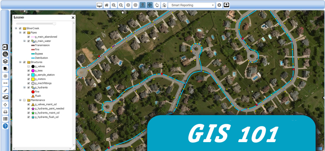
5 Things You NEED to Know Before Choosing a GIS Solution. 

GIS has become something of a buzzword these days, but that doesn’t mean that it isn’t a critical part of a healthy organization’s toolkit to manage assets, track maintenance, and provide access to maps and data to people who need it.
​

If you are new to GIS or aren’t sure where to start, choosing a GIS professional to work with is a smart first choice. There are a lot of options to choose from when it comes to choosing a GIS solution and a GIS professional can help you learn about the pros and cons of each one. When choosing a GIS solution, consider the following 5 tips to get you started in the right direction.
  1. Don’t throw away your existing data! Do you already have some assets that are geo-referenced? Do you have data that is accurate but not complete? Don’t start from scratch—the company you choose to work with should be able to leverage your existing data and help you complete missing data using sources like paper maps, CAD drawings, spreadsheets, and databases.
  2. Leverage your existing maps. Your GIS solution should have the ability to make paper maps accessible in the field. Do you have old CAD drawings? Your GIS provider should be comfortable taking old drawings and referencing them to help build your GIS or converting them to your GIS.
  3. Identify a coordinate system.  Identifying the correct coordinate system is key and the first step to ensure all your assets and data are spatially accurate. Using no coordinate system or the incorrect coordinate system will project geometry features to the wrong location.
  4. Incorporate high-resolution aerial photography to your maps. A picture may be worth a thousand words but when it comes to GIS, adding high-resolution aerial photography can make the difference between quickly finding an asset or wasting time searching for it. Your GIS provider should be able to help you gain access to affordable high-resolution aerial photographs to enhance your GIS imagery.
  5. Plan on having a connectivity model. Is your utility system snapped correctly or do you have loops or missing open points? A connectivity model is part of a healthy GIS. If your data doesn’t support a connectivity mode it is crucial you choose a GIS provider that can analyze and test your connectivity model to help close the gap and create a working, traceable model.

If you are looking for a GIS solution, mPower Innovations can help you find a solution that leverages your existing data and provides you with powerful reporting and tools that your entire organization can use. Our solutions are adaptable to your work flow and can work with your existing software solutions. If you are looking for a GIS solution, contact mPower today to learn how we can help you find a GIS solution that is cost effective, easy to implement, and powerful.

6 Comments
custom essay writers link
10/2/2018 11:14:43 pm

It's so easy to come up with such lists of things to do and things we should know. Honestly, with the rate of how easy it is for anyone to just upload stuff which are not really backed by research but can easily be accessible to anyone, we don't know what to believe anymore. If we have a little background of the subject, then maybe we have a chance to do away with wrong information. I think everything you mentioned here makes sense and if you ask a professional, he will say you really know the subject matter by heart.

Reply
custom cartography link
6/29/2020 11:05:11 am

Be sure to take your time when choosing a new GIS solution, and always be sure to talk to a professional. Thanks for sharing.

Reply
Essay Writing Service link
1/28/2021 03:43:17 am

Geographic Information System education has gone from a limited direction to an endless journey that is capable of providing us with all the information you need about the science of geography.

Reply
Kelly link
4/11/2022 07:25:56 am

When I'm deciding upon a GIS software, being easy to use is one of the major criteria. Because it takes a lot of time to train someone on a new software. Thanks again for this checklist!

Reply
Metal Roofing Gilbert link
8/21/2022 02:51:32 pm

Good posst

Reply
Rocky Mount Solar Panels link
5/13/2024 11:27:16 pm

Great readinng

Reply


Leave a Reply.

    RSS Feed

Picture

Home  | Software  |  Services   | Contact Us


​Terms & Conditions | Privacy Policy
​

​Toll-free: 877-269-6971


  • Home
  • SOFTWARE
    • OUR SOFTWARE
    • GIS-Based Asset Management
    • Integrator™
    • Meter Data Analysis
    • Outage Management System
    • Work Management System
    • FiberPro
    • IVR Interactive Voice Response
    • eReliability Sync
    • Form Builder
    • Vegetation Management
    • Meter Change Out Application
  • SERVICES
    • Meter Data Analysis
    • GPS Data Collection
    • Joint Use Pole Audit
    • Map Cleanup and Conversion
    • Mapping Software Training
    • Utility Modeling Services
    • SQL Database Services
  • MARKETS
    • ELECTRIC UTILITIES
    • Water Utilities
    • GAS UTILITIES
    • Broadband / Telecom
    • Municipalities & Cities
    • CAMPUSES AND INSTITUTIONS
  • CONTACT
    • CONTACT US
    • Free Data Review
    • Request a Services Quote
    • LOG A SUPPORT TICKET
  • Resources
    • Customer Resources >
      • Customer Portal
      • Customer Portal Registration
      • LOG A SUPPORT TICKET
  • About
    • Our Company
    • MEMBERSHIPS & ASSOCIATIONS
    • PARTNERS
    • Careers
  • Videos
    • Recorded Webinars
  • 2025 User Group Conference
    • 2025 User Group Registration
    • 2025 User Group Hotel Reservation
    • 2025 User Group Sponsors