GIS for Campuses and Institutions
Take Control of Your Maps and Data
|
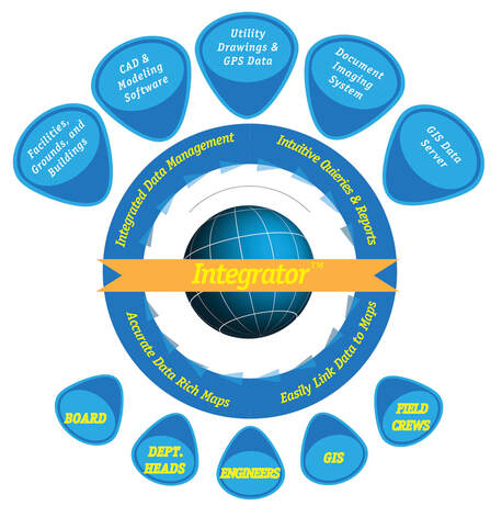
Your most important asset is your data.
Whether on a college or commercial campus, mPower understands how difficult it is to manage all the information, keep costs down, and get the job done. That’s why mPower's Software Solution, Integrator, makes asset data instantly accessible, with unlimited flexibility to analyze and report on the system parameters of your choosing. Forget about using clumsy, outdated maps. With Integrator, all personnel can access maps and live data from any computer, anywhere there is access to the internet or intranet! Easily share up-to-date maps and data with Administration and Management, Operations & Maintenance, Planning & Construction, and Energy & Utilities. Our latest software versions support all GIS/Mapping platforms including Esri, Autodesk, GE Smallworld, and Arc FM. |
Trace Flow Analysis & Incident Management
Reduce outage times and manage emergencies better with browser-based mapping.
Integrator enables you to plot problem areas such as: broken pipes, inoperable valves, and sources or destinations of contamination, on to the map, as they are identified. Then, Integrator’s embedded trace flow capability can be used
to identify the root cause quickly and efficiently.
Once the situation is resolved, reporting and damage assessments are a snap using the built-in reporting tools.
Preventative & Predictive Maintenance

|
Integrator helps to prevent future problems.
Analyze and report on system parameters such as: materials, construction type/date, vendor, historical problem areas, etc. Need to notify building managers, personnel, or residents of an emergency or scheduled service interruption? Integrator will automate the process of identifying any asset and notify interested parties immediately. Our new maintenance management extension ties into existing Computerized Maintenance Management Systems. |
How customers are using our GIS solutions

Ferris State University deploys mPower’s web-based solution to help manage, maintain, and monitor GIS data, which enables sharing and distribution of GIS and emergency management data with other agencies quickly.
Implementation times are drastically reduced, and custom development is accomplished without expensive and time-consuming programming or outsourced consulting. With the use of mPower integrator software, Ferris State University can share the necessary information to the proper departments and the public over a web-based platform, allowing for instant access to everyone’s needs.
Implementation times are drastically reduced, and custom development is accomplished without expensive and time-consuming programming or outsourced consulting. With the use of mPower integrator software, Ferris State University can share the necessary information to the proper departments and the public over a web-based platform, allowing for instant access to everyone’s needs.
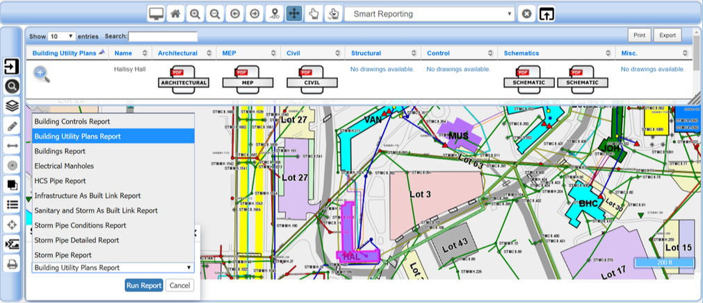
Intuitive, point and click wizards help you create dynamic, customized, reports fast and easy, without the need for expensive custom programming. mPower's Integrator Solution makes GIS for campuses and institutions easy, affordable, and most importantly powerful. |
“mPower’s Integrator software program effectively integrates geo-spatial data for all University Campus Stakeholders at Ferris State University. This utility mapping system provides for an effective and efficient path for professional service organizations to quickly obtain the most recent and historical architectural, mechanical, electrical and civil infrastructure and building drawings. Integrator is an intuitive system, it takes only a few minutes to learn how to use it to access campus data. In my opinion, I believe Integrator is the best tool for our needs.” - Daniel G. Sovinski, PE, CEM Power Plant Manager and Physical Plant Engineer Ferris State University |
Modular solutions deliver scale and flexibility to provide key management tools for all sizes of institutions.
IntegratorEasily integrate GIS, Outage Management and Smart Grid systems, allowing you to put the right data in the right hands when it matters most. mPower Integrator™ and mPower OMS™ are uniquely powerful, yet easy to use browser-based mapping/GIS tools that facilitate; asset management, outage response, load analysis/balancing, trace flow analysis and more. The software easily connects any compliant database (ODBC) allowing secure access, reporting and distribution of maps and data. mPower’s software solutions seamlessly interface with AMR/AMI, AVL, CIS, IVR, MDM, OMS, and other Mapping, Modeling and Staking systems. This gives you access to all of your various systems (and their data) through one simple, “smart map” interface. Learn more. mPower Outage Management System (OMS)Improve Customer Service by putting the right resources in the right places as efficiently and effectively as possible.
mPower Automated Vehicle LocatorThe simple, reliable and cost effective solution to track your vehicles in the field.
|
AMI OMS ListenerTap the power of your AMI system, with automated, industry-standard interface between your AMI and OMS. Automatically update your maps and OMS with outage and restoration calls from your meters. Fully Integrate Your AMI and OMS Systems:
mPower Mobile EditorCapture Accurate Data From Any Location with mPower Editor’s Flexible Forms. The flexibility of mPower Editor efficiently delivers clean data to any system and back to the field. Bridge the communication gap between field and office personnel, with easy to build, user-definable forms for Work Orders, Inspections, Asset Change-outs and more. Tablets, PCs and Smart Phones quickly become powerful tools to keep utility data correct and up to date. mPower Load AnalysisSave Time and Money with the Ability to Intelligently Analyze And Balance Your Load, by merging load data from your metering system with CIS usage data and your connectivity model.
|

|
|