GIS-Based Asset Management
|
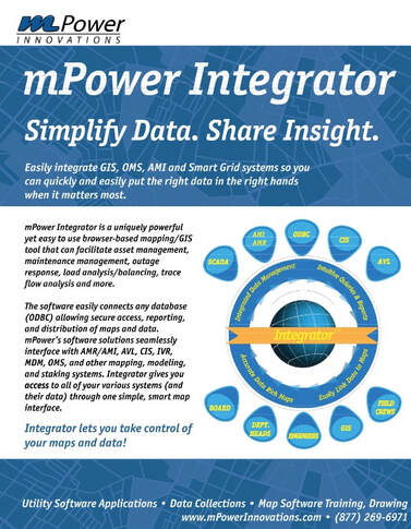
What is Integrator™?
Integrator™ is our GIS-based Asset Management and System Integration program for utilities and institutions. With Integrator™ you can build a GIS-based database of all your system assets that includes their GPS location and any important data and attribute information or features you want listed (material, diameter, class, manufacturer, inspection videos, etc.). Once your assets are in Integrator™, you can build custom forms to add, update, and maintain your asset information. Integrator™ makes it easy to build forms and because it's browser-based, forms can be filled out in the field on a smartphone or tablet. By recording maintenance activities in the field, you can keep your GIS and system attributes up to date and build a true system of record. Integrator™ also gives you the ability to capture photos in the field and capture XY coordinates to locate assets easily on your map or in the field. |
|
What makes Integrator™ different?
Integrator™ is so much more than an asset management tool. It has the unique ability to easily connect to any OBDC compliant database allowing secure access, reporting and distribution of maps and data of your entire system.
Integrator™ is so much more than an asset management tool. It has the unique ability to easily connect to any OBDC compliant database allowing secure access, reporting and distribution of maps and data of your entire system.
Integrator™ seamlessly interfaces with AMR/AMI, AVL, CIS, IVR, MDM, OMS, and other Mapping, Modeling and Staking systems. Integrator gives you access to all of your various systems (and their data) through one simple, “smart map” interface. Integrator™ gives the end-user the ability to run powerful reports and analysis on multiple data sources from one screen.
Applications of Integrator are only limited by your imagination. Other uses for Integrator include:
Applications of Integrator are only limited by your imagination. Other uses for Integrator include:
- Maintenance Management
- Vegetation Management
- Work Management
- Public Outage Maps
- Advanced Load Analysis
- Facilities Management
- Cemetery Management
- Parks and Recreation Management
|
|