mPower Innovations - GIS Software and Services for Utilities and Institutions
  • Home
  • SOFTWARE
    • OUR SOFTWARE
    • GIS-Based Asset Management
    • Integrator™
    • Meter Data Analysis
    • Outage Management System
    • Work Management System
    • Fiber Management
    • Staking Software
    • IVR Interactive Voice Response
    • eReliability Sync
    • Form Builder
    • Vegetation Management
    • Meter Change Out Application
  • SERVICES
    • Meter Data Analysis
    • GPS Data Collection
    • Joint Use Pole Audit
    • Map Cleanup and Conversion
    • Mapping Software Training
    • Utility Modeling Services
    • SQL Database Services
  • MARKETS
    • ELECTRIC UTILITIES
    • Water Utilities
    • GAS UTILITIES
    • Municipalities & Cities
    • CAMPUSES AND INSTITUTIONS
  • CONTACT
    • CONTACT US
    • Free Map & Data Review
    • Request a Services Quote
    • LOG A SUPPORT TICKET
  • Resources
    • Customer Resources >
      • Customer Portal
      • Customer Portal Registration
      • mPower User Forum
      • User Group Conference
      • LOG A SUPPORT TICKET
    • TESTIMONIALS
    • News & Updates
    • FAQs
  • About
    • Our Company
    • MEMBERSHIPS & ASSOCIATIONS
    • PARTNERS
    • Careers
  • Videos
    • Recorded Webinars
  • UPCOMING WEBINARS
    • Upcoming Webinars
    • Fiber Management Webinar
    • Water Utility Webinar

mPower Staking Software

mPower Staking Software

Staking, Design & Cost Estimating

Download Brochure
View Video Demo
Get a Quote
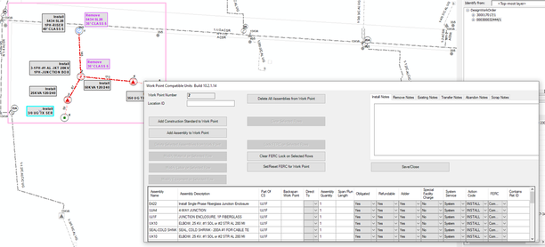
mPower Staking Software (Falcon) is a GIS toolset that provides field staking, design and costing for new projects.
The toolset consists of an ArcGIS Desktop environment that prepares the field staking package.
A field staking package allows the staking technician to place work points on the map
​and assign material and assemblies to the work points. 

After the field work is completed, the data is uploaded back into the GIS
​where the staking sheets/material lists/costs are generated. 
Picture
GIS toolset for field staking, design & costing new projects
Works with Collector for ArcGIS and Field Maps for ArcGIS
Tracks construction standards, assemblies,
​material, labor and equipment
Includes reporting and analysis functions
Picture
Picture

Home  | Software  |  Services   | Contact Us


​Terms & Conditions | Privacy Policy
​

​Toll-free: 877-269-6971


  • Home
  • SOFTWARE
    • OUR SOFTWARE
    • GIS-Based Asset Management
    • Integrator™
    • Meter Data Analysis
    • Outage Management System
    • Work Management System
    • Fiber Management
    • Staking Software
    • IVR Interactive Voice Response
    • eReliability Sync
    • Form Builder
    • Vegetation Management
    • Meter Change Out Application
  • SERVICES
    • Meter Data Analysis
    • GPS Data Collection
    • Joint Use Pole Audit
    • Map Cleanup and Conversion
    • Mapping Software Training
    • Utility Modeling Services
    • SQL Database Services
  • MARKETS
    • ELECTRIC UTILITIES
    • Water Utilities
    • GAS UTILITIES
    • Municipalities & Cities
    • CAMPUSES AND INSTITUTIONS
  • CONTACT
    • CONTACT US
    • Free Map & Data Review
    • Request a Services Quote
    • LOG A SUPPORT TICKET
  • Resources
    • Customer Resources >
      • Customer Portal
      • Customer Portal Registration
      • mPower User Forum
      • User Group Conference
      • LOG A SUPPORT TICKET
    • TESTIMONIALS
    • News & Updates
    • FAQs
  • About
    • Our Company
    • MEMBERSHIPS & ASSOCIATIONS
    • PARTNERS
    • Careers
  • Videos
    • Recorded Webinars
  • UPCOMING WEBINARS
    • Upcoming Webinars
    • Fiber Management Webinar
    • Water Utility Webinar