mPower Innovations - GIS Software and Services for Utilities and Institutions
  • Home
  • SOFTWARE
    • OUR SOFTWARE
    • GIS-Based Asset Management
    • Integrator™
    • Meter Data Analysis
    • Outage Management System
    • Work Management System
    • Fiber Management
    • Staking Software
    • IVR Interactive Voice Response
    • eReliability Sync
    • Form Builder
    • Vegetation Management
    • Meter Change Out Application
  • SERVICES
    • Meter Data Analysis
    • GPS Data Collection
    • Joint Use Pole Audit
    • Map Cleanup and Conversion
    • Mapping Software Training
    • Utility Modeling Services
    • SQL Database Services
  • MARKETS
    • ELECTRIC UTILITIES
    • Water Utilities
    • GAS UTILITIES
    • Municipalities & Cities
    • CAMPUSES AND INSTITUTIONS
  • CONTACT
    • CONTACT US
    • Free Map & Data Review
    • Request a Services Quote
    • LOG A SUPPORT TICKET
  • Resources
    • Customer Resources >
      • Customer Portal
      • Customer Portal Registration
      • mPower User Forum
      • User Group Conference
      • LOG A SUPPORT TICKET
    • TESTIMONIALS
    • News & Updates
    • FAQs
  • About
    • Our Company
    • MEMBERSHIPS & ASSOCIATIONS
    • PARTNERS
    • Careers
  • Videos
    • Recorded Webinars
  • UPCOMING WEBINARS
    • Upcoming Webinars
    • Fiber Management Webinar
    • Water Utility Webinar

News & Updates

City of Windom, MN selects mPower Innovations for an enterprise GIS solution to help manage their utility infrastructure

6/16/2020

0 Comments

 
Picture
Windom, MN May 28, 2020 – On February 20th, the Utility Commission at City of Windom unanimously approved a proposal from mPower Innovations to provide a powerful enterprise GIS solution to track their electric, water, and wastewater data on one map. This system will help the City of Windom support its goal of constantly working to improve and provide reliable service to their residents.

The City of Windom will utilize mPower’s Integrator software, a powerful web-based GIS asset management and system integration application that will enable the City of Windom to view and update all of their utility assets and access critical information from one browser-based system—eliminating the tedious process of searching for information in multiple sources and maps. Moving to a GIS-based asset management system will dramatically improve communication and response time to planned and unplanned service interruptions and maintenance.

 “After watching a software demonstration at an MMUA (Minnesota Municipal Utilities Association) conference, I could see their software provided the control and access that we were looking for that our existing software was lacking.” said Jason Sykora, Electric Superintendent.

Greg Calcari, the Founder of mPower Innovations added, “Partnering with mPower is going to greatly enhance the maps and data of the City of Windom’s multiple utility departments and give them the ability to take control of their own data without relying on a third-party to update their maps and data.”
​
The City of Windom is the latest in a growing list of Minnesota municipal customers of mPower. Despite initial delays with the Covd-19 pandemic, the city completed the onboarding process in March and now has a fully deployed GIS solution. 

0 Comments

City of Wakefield, MI selects mPower Innovations for an enterprise GIS solution to help manage their municipal and utility infrastructure

12/26/2019

0 Comments

 
Picture
​Iron Mountain, MI and Wakefield, MI December 26, 2019 -- Last month the City of Wakefield unanimously approved a proposal from mPower Innovations to provide a powerful enterprise GIS solution to help digitize their electric and water system assets and maintenance processes. This system will help the City of Wakefield support its goal of constantly working to improve and provide reliable service to their residents.

The City of Wakefield will utilize mPower’s Integrator software, a powerful web-based GIS asset management and system integration application that will enable the City of Wakefield to view and update all of their utility assets and access critical information from one browser-based system—eliminating the tedious process of searching for information in multiple sources and maps. Moving to a GIS-based asset management system will dramatically improve communication and response time to planned and unplanned service interruptions and maintenance.

 “With mPower, the City of Wakefield will leap into the 21st Century by deploying powerful technology that will provide City Staff with quick access to information, dynamic reports, and the ability to track an accurate inventory of City assets. In addition, residents will be able to view and report power outages and submit work orders from the comforts of their mobile devices. The City of Wakefield is excited to deploy this software in the coming months,” said Robert Brown Jr, City Manager of Wakefield.

Jason Brown, President and CEO of mPower Innovations added, “Partnering with mPower is a positive signal that the City of Wakefield is embracing new technology and committed to the residents and customers they serve. Building a solid GIS is critical to the maintaining an efficient, safe, and reliable utility.”

The City of Wakefield is one of mPower’s many Michigan municipal customers. The city has completed the onboarding process and is expected to have a fully functional GIS solution by the end of the year.
0 Comments

New Testimonial from Scott Ham, General Manager of Silver Creek Water Authority

10/22/2018

0 Comments

 
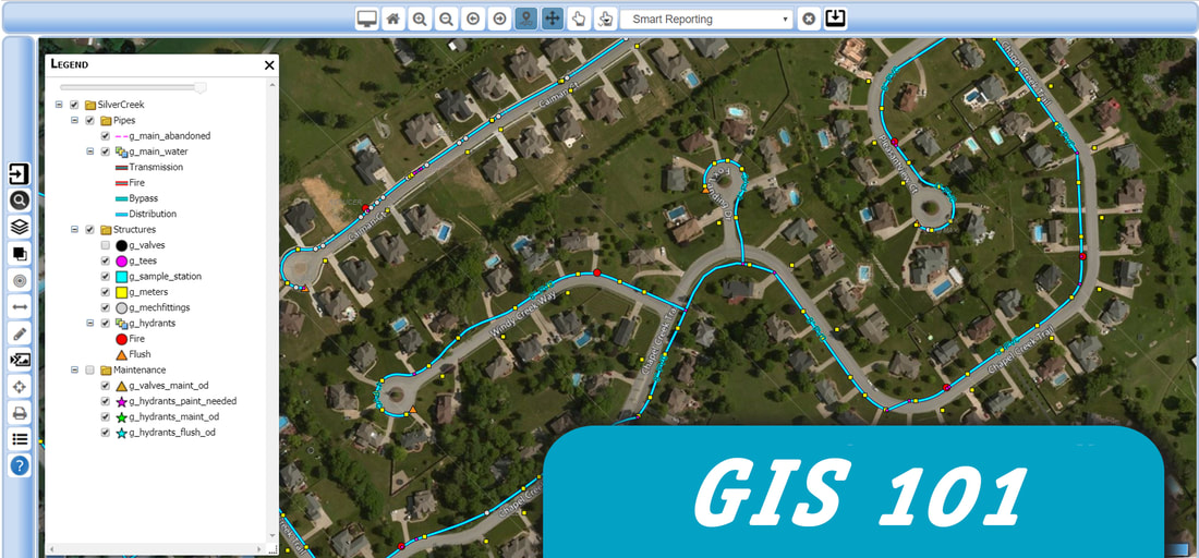
At our User Group Conference in October we caught up with Scott Ham, General Manager of Silver Creek Water Authority in Sellersburg, Indiana and asked him about his experience working with mPower Innovations. Watch his testimonial below!
0 Comments

FIVE THINGS YOU NEED TO KNOW BEFORE CHOOSING A GIS SOLUTION.

7/25/2018

5 Comments

 
Picture

5 Things You NEED to Know Before Choosing a GIS Solution. 

GIS has become something of a buzzword these days, but that doesn’t mean that it isn’t a critical part of a healthy organization’s toolkit to manage assets, track maintenance, and provide access to maps and data to people who need it.
​

If you are new to GIS or aren’t sure where to start, choosing a GIS professional to work with is a smart first choice. There are a lot of options to choose from when it comes to choosing a GIS solution and a GIS professional can help you learn about the pros and cons of each one. When choosing a GIS solution, consider the following 5 tips to get you started in the right direction.
  1. Don’t throw away your existing data! Do you already have some assets that are geo-referenced? Do you have data that is accurate but not complete? Don’t start from scratch—the company you choose to work with should be able to leverage your existing data and help you complete missing data using sources like paper maps, CAD drawings, spreadsheets, and databases.
  2. Leverage your existing maps. Your GIS solution should have the ability to make paper maps accessible in the field. Do you have old CAD drawings? Your GIS provider should be comfortable taking old drawings and referencing them to help build your GIS or converting them to your GIS.
  3. Identify a coordinate system.  Identifying the correct coordinate system is key and the first step to ensure all your assets and data are spatially accurate. Using no coordinate system or the incorrect coordinate system will project geometry features to the wrong location.
  4. Incorporate high-resolution aerial photography to your maps. A picture may be worth a thousand words but when it comes to GIS, adding high-resolution aerial photography can make the difference between quickly finding an asset or wasting time searching for it. Your GIS provider should be able to help you gain access to affordable high-resolution aerial photographs to enhance your GIS imagery.
  5. Plan on having a connectivity model. Is your utility system snapped correctly or do you have loops or missing open points? A connectivity model is part of a healthy GIS. If your data doesn’t support a connectivity mode it is crucial you choose a GIS provider that can analyze and test your connectivity model to help close the gap and create a working, traceable model.

If you are looking for a GIS solution, mPower Innovations can help you find a solution that leverages your existing data and provides you with powerful reporting and tools that your entire organization can use. Our solutions are adaptable to your work flow and can work with your existing software solutions. If you are looking for a GIS solution, contact mPower today to learn how we can help you find a GIS solution that is cost effective, easy to implement, and powerful.

5 Comments
    Picture

    About us

    mPower is a full-service, one-stop-shop for utilities and organizations at any stage of GIS and Smart Grid integration. Learn more about our company here. 

    Archives

    August 2021
    April 2021
    February 2021
    December 2020
    August 2020
    June 2020
    March 2020
    December 2019
    May 2019
    October 2018
    July 2018
    April 2018
    March 2018
    January 2018

    Categories

    All
    Acquisition
    Alabama
    Appa
    Asset Management
    Cherokee Electric Coop
    Community
    Conference
    COOP
    Coronavirus
    Covid 19
    Customer Support
    Electric Utility
    Exhibition
    Fiber
    GIS
    GIS Software
    GIS Solutions
    Governor's Office Of Storm Recovery
    Jason Brown
    Kansas Municipal Utilities
    KMU
    Mapping
    MI
    Minnesota
    Minnesota Municipal Utilities Association
    Minnesota Rural Water Association
    MMUA
    MNRWA
    MPower Innovations
    MPower Innovations News
    Municipal Infrastructure
    Municipality
    New Staff
    Niagara
    OMS
    Ptarmigan
    Rural Water Association Of Utah
    Scott Mossbrooks
    Staking
    Testimonial
    Tips For GIS
    Tradeshow
    User Group Conference
    User Group Forum
    Village Of Freeport
    Wakefield
    Water Utilities
    Water Utility
    WI
    Wichita
    Windom

    RSS Feed

    MPower Innovations Inc.
Picture

Home  | Software  |  Services   | Contact Us


​Terms & Conditions | Privacy Policy
​

​Toll-free: 877-269-6971


  • Home
  • SOFTWARE
    • OUR SOFTWARE
    • GIS-Based Asset Management
    • Integrator™
    • Meter Data Analysis
    • Outage Management System
    • Work Management System
    • Fiber Management
    • Staking Software
    • IVR Interactive Voice Response
    • eReliability Sync
    • Form Builder
    • Vegetation Management
    • Meter Change Out Application
  • SERVICES
    • Meter Data Analysis
    • GPS Data Collection
    • Joint Use Pole Audit
    • Map Cleanup and Conversion
    • Mapping Software Training
    • Utility Modeling Services
    • SQL Database Services
  • MARKETS
    • ELECTRIC UTILITIES
    • Water Utilities
    • GAS UTILITIES
    • Municipalities & Cities
    • CAMPUSES AND INSTITUTIONS
  • CONTACT
    • CONTACT US
    • Free Map & Data Review
    • Request a Services Quote
    • LOG A SUPPORT TICKET
  • Resources
    • Customer Resources >
      • Customer Portal
      • Customer Portal Registration
      • mPower User Forum
      • User Group Conference
      • LOG A SUPPORT TICKET
    • TESTIMONIALS
    • News & Updates
    • FAQs
  • About
    • Our Company
    • MEMBERSHIPS & ASSOCIATIONS
    • PARTNERS
    • Careers
  • Videos
    • Recorded Webinars
  • UPCOMING WEBINARS
    • Upcoming Webinars
    • Fiber Management Webinar
    • Water Utility Webinar